


Kabah, full of surprises
Not long ago I returned to the Maya city of Kabah after nearly ten years, and it managed to surprise me all over again. Let me tell you why.
For most visitors, exploring the Puuc Route—the hilly region in southern Yucatán that brings together several ancient Maya cities sharing a common history and distinctive architectural style—usually means visiting Uxmal. The other archaeological sites along the route (Sayil, Labná, Xlapak, and Kabah) tend to be overlooked.
Perhaps that's because, although they're all connected by Federal Highway 261, reaching them isn't particularly easy if you're traveling without a car. Public transportation is limited and unreliable, making a rental car your best option. Keep your eyes open, though: the signage isn't especially helpful, and it's surprisingly easy to drive right past the entrance. Ironically, this road has been in use for at least two centuries, having once served as the old route to Bolonchén, in neighboring Campeche.
This time, I decided to focus exclusively on this, one of the smaller sites. "Smaller" is a relative term, of course: the section of Kabah that’s open to visitors covers less than two square kilometers, but the ancient city extends well beyond that, with numerous structures still awaiting excavation and restoration. The same highway that links the Puuc sites cuts directly through the archaeological zone, dividing its monuments between both sides of the road.
Kabah receives surprisingly few visitors. One of the site's staff members told me that even during the busiest season, it averages only around 200 visitors a week.
Archaeological evidence suggests that Kabah has existed for well over a thousand years, with occupation dating back as early as CE 200. Its greatest period of prosperity, however, came between CE 700 and 1000, when nearly all of the buildings visitors see today were constructed. After that, the city was gradually abandoned—but never forgotten. Centuries later, it was still remembered in the Chilam Balam of Chumayel, one of the best-known Maya historical and prophetic texts.
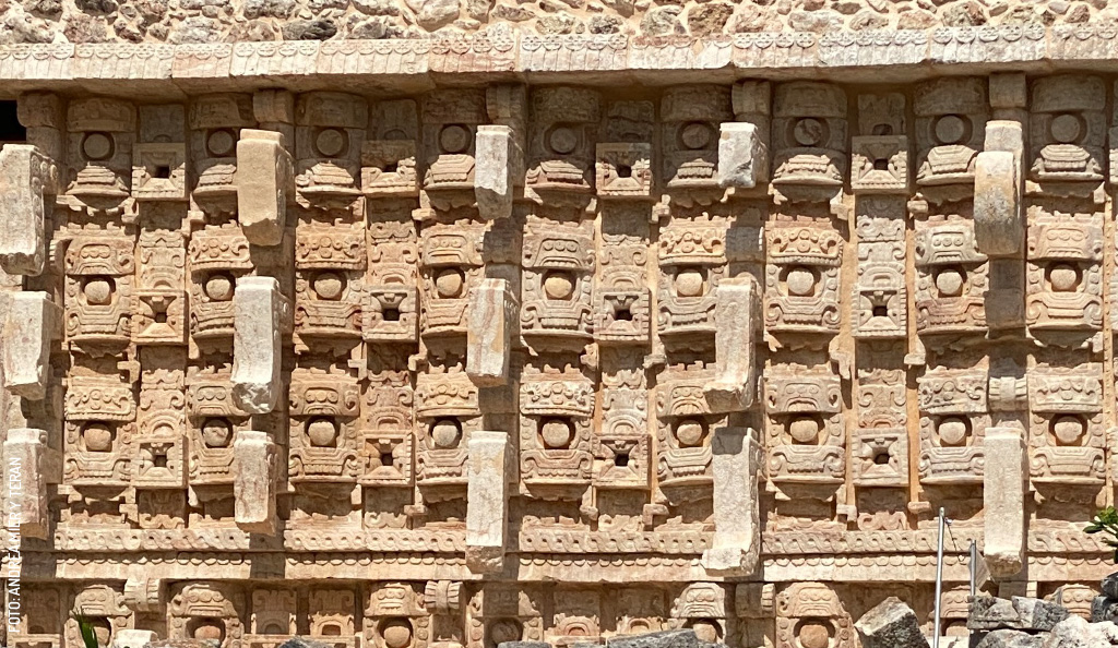
In fact, Kabah is one of the few ancient Maya cities whose original name has survived. It is generally translated as "the lord of the mighty hand," or simply "the mighty hand." I've often wondered whether that name reflects the city's importance as a ceremonial center. One thing is certain: references to Chaac, the Maya god of rain, wind, and thunder, appear throughout the site, especially on its most famous building, the Codz Pop.
The Codz Pop
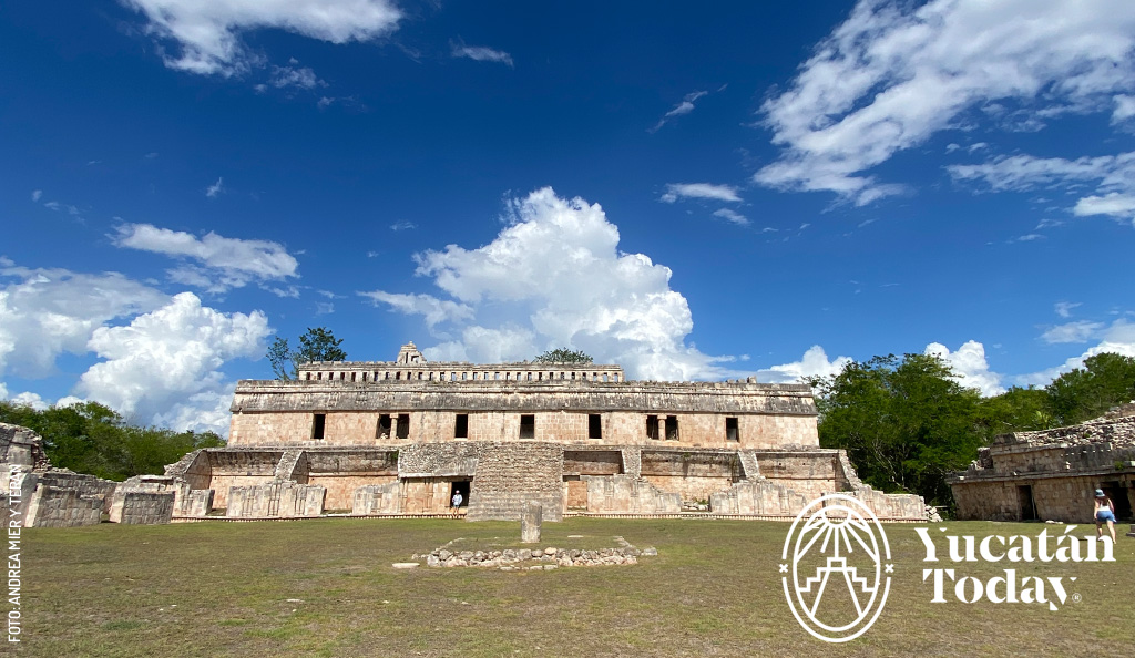
Also known as the Temple of the Masks, the Codz Pop stands atop a platform just to the right of the site's main entrance. It's not only the highlight of Kabah, but one of the architectural masterpieces of the entire Puuc Route—and arguably of the northern Maya world.
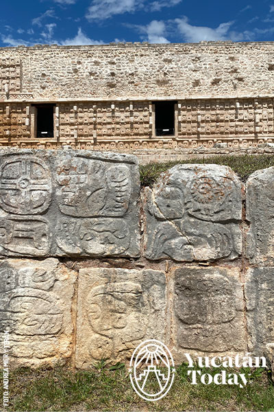
Before focusing on the building itself, take a moment to look across the plaza in front of it. At its center stands an altar carved with hieroglyphic inscriptions. Scattered around it are carefully arranged groups of carved stones, lined up almost like giant puzzle pieces waiting to be put back together. They almost certainly once belonged to the structure and now patiently await their turn to return to their original place.
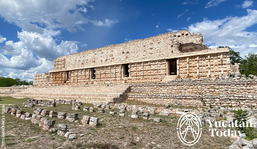
Now, turn your attention to the Codz Pop itself. Its façade has sometimes been described as "Maya Gothic" for its spectacular profusion of geometric mosaics, latticework, and elaborate stone decoration that once covered virtually every inch of the building. Archaeologists estimate that it originally displayed more than 300 representations of the face of Chaac.
Why such devotion to this particular deity? The answer may lie in geography. Unlike much of northern Yucatán, the Puuc region has no cenotes or natural waterholes. The area’s inhabitants depended almost entirely on rainfall for survival, placing their fate in the hands of Chaac. Through ceremonies and offerings, they sought his favor, hoping he would send rain to nourish their fields. The precious water was then stored in underground cisterns known as chultunes, more than a dozen of which have been identified throughout Kabah.
Before moving on, pause for a moment and take in your surroundings. Tall trees envelop the site in every shade of green imaginable. The forest is alive with birds—motmots, woodpeckers, parrots, even vultures—and somewhere beyond the visitor trails, they say, jaguars still roam.
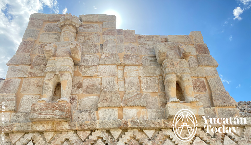
As spectacular as the front of the Codz Pop may be, the rear façade is equally impressive. Near the top stand two sculptures of a male figure—originally there were seven. Archaeologists believe they depict one of Kabah's rulers, who also appears carved into the doorways below in scenes of warfare. The poses are regal, yet remarkably dramatic, giving the building an almost theatrical presence.
Today’s Tip:
Venture out to the sides, come closer and farther, squat and stretch yourself out: the building is so symmetrical and so beautiful, you’ll want to take lots of pictures, and you’ll want to make sure you’re getting the best angle.
The Square
Just off to the left there is a square framed by three remarkable structures: the Palace, the House of the Royal Emblem, and the Teocalli. The Palace is the largest and most imposing, with traces of an elaborate roof comb still visible along its upper edge, while the House of the Royal Emblem offers plenty of striking architectural details. My favorite, however, is the Teocalli.
Fun fact: Teocalli is a pre-Hispanic word that means “house of god”, but it isn’t Maya: it’s náhuatl, the language spoken in what now is Central México.
There's a simple reason why. Beside one of its exterior stairways, a bitter orange tree casts its shade across the ancient stones, adding a splash of color to the building. It's a charming sight—a quiet reminder that Kabah's past and present have long been intertwined with agriculture. In fact, English explorer John Lloyd Stephens wrote of cornfields stretching around Kabah when he visited the site in the 1840s.
It was Stephens' vivid descriptions, together with the engravings and drawings of Frederik Catherwood, published in Incidents of Travel in Central America, Chiapas, and Yucatán in 1841, that first captured the imagination of scholars, travelers, and fellow adventurers—including the French explorer Désiré Charnay—and helped spark worldwide fascination with the ancient Maya.
And since we're talking about imagination, here's another fun tidbit. According to local legend, Kabah was once home to the old woman who found the mysterious egg from which the tiny hero of the famous Legend of the Dwarf of Uxmal was born. It was that very dwarf, the tale says, who would later build Uxmal's iconic Pyramid of the Magician overnight.
Crossing the Road: The Arch of Kabah
Now let's head to the other side of the highway, where a rustic trail disappears into the forest. Along the way you'll catch glimpses of ancient structures hidden among the vegetation, many still in different stages of excavation and restoration. For obvious reasons, visitors can't approach them yet. One can't help but wonder: how many more years before they're opened to the public?
A little farther on, just beyond a gentle curve, you'll reach the reason for following this path: the Arch of Kabah. It's a single structure, modest in scale yet striking in appearance, standing out against the surrounding sea of green. Early explorers called it a "Triumphal Arch," but they were mistaken: it wasn't built to commemorate military victories; it simply marked one of the city's entrances—or exits.
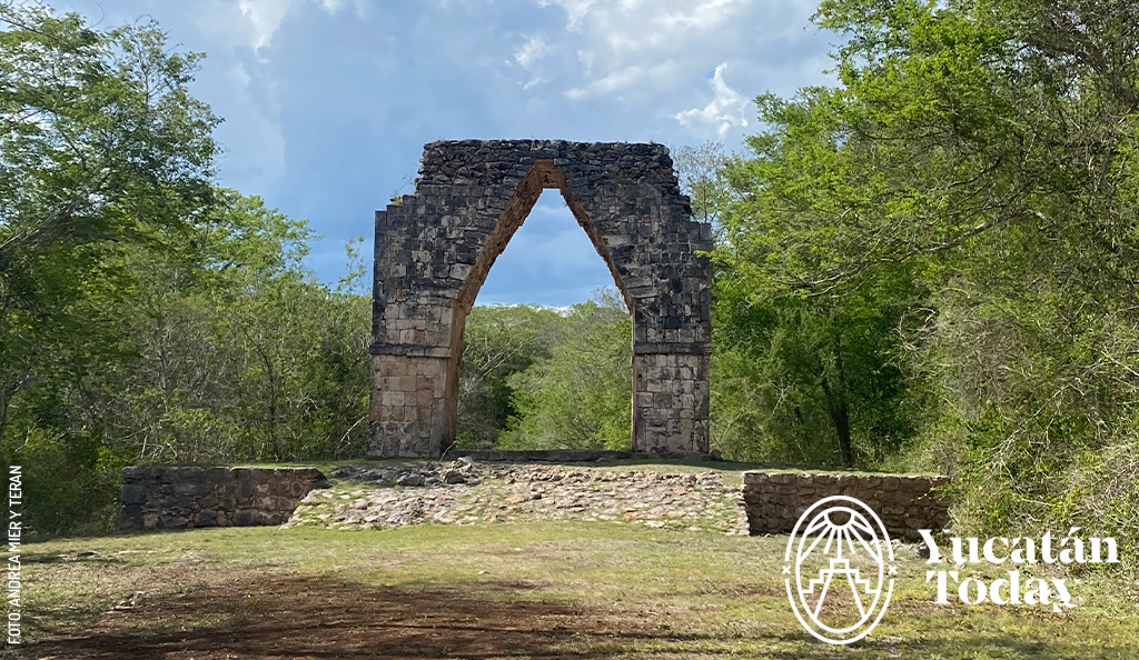
The arch also served as the beginning (or end) of a sacbé, the ancient white road that connected Kabah with Uxmal, some 23 kilometers away. Standing alone amid the forest, austere and serene, it feels less like a monument and more like a quiet farewell from the ancient city.
I glance at my watch and realize that two hours have flown by—and it still feels like a short time to discover all of the things I’ve seen: hieroglyphs, palaces, chultunes, gods, terraces, sculptures, legends, nineteenth-century explorers, iguanas, butterflies, birds everywhere... and even a humble bitter orange tree.
There's no doubt about it: Kabah is full of surprises.
Kabah Archaeological Site (Kabah ruins)
Carr. 261, 140 km (87 mi) south of Mérida, 23 km (14 mi) southeast of Uxmal
Location: Google Maps
Every day 8 am - 5 pm
Services: Restrooms, certified guides, handicrafts, snacks, and beverages. The site currently does not offer ramps or other accessibility features for older adults or visitors with disabilities.
Admission fee: $155 pesos, or $85 pesos for Mexican citizens and permanent residents.
Publicado por primera vez en el sitio web de Yucatán Today en agosto del 2026.


Related articles


