

Hurricane Season in Yucatán 2026
Hurricane season in Yucatán
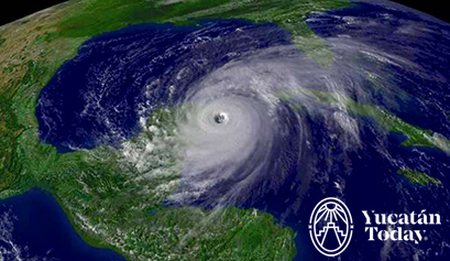
The hurricane season in Yucatán is actually the Gulf's tropical cyclone season; this means it's important to keep an eye on not just hurricanes, but also tropical depressions and storms.
Tropical depressions and storms have winds between 40 and 117 km/h (or 24 and 72 mph). Once they reach 118 km/h (73 mph), these weather phenomena are considered hurricanes. There are five levels of hurricanes; according to the Saffir-Simpson intensity scale, these range from Category 1 (with wind speeds between 118 and 153 km/h, or 75 and 95 mph) to Category 5 (winds exceeding 250 km/h or 155 mph).
The NOAA 2026 Atlantic Hurricane Season Outlook predicts a below-normal season (running June 1 to November 30) due to a developing El Niño. Forecasters estimate 8 to 14 named storms, 3 to 6 hurricanes, and 1 to 3 major hurricanes. This means a 55% chance of below-average activity.
What to expect during hurricane season in Yucatán
In Yucatán, most houses are made of metal and concrete, making them very safe against the strong winds during the tropical cyclone season. However, it’s true that at these wind speeds, extreme damage can occur, and if the hurricane brings rain, it can cause severe damage as well.
On the coast, the sea can gain unexpected strength and destroy whatever is in its path; depending on the severity of the threat, authorities might urge people in those areas to evacuate. If this happens, don’t ignore their recommendations; the sea can completely destroy even the most solid concrete structures.
But don’t be afraid: hurricanes are seen coming days in advance, and it’s unlikely they will catch us by surprise. Here are some recommendations.
Early warning system for tropical cyclones in Yucatán
What does the blue hurricane alert mean in México?
What does the green hurricane alert mean in México?
What does the yellow hurricane alert mean in México?
What does the orange hurricane alert mean in México?
What does the red hurricane alert mean in México?
If you visit Yucatán during hurricane season (between June and November), the most important thing is to stay updated with alerts and rely only on verified sources. If a hurricane is approaching the Península, you’ll likely see satellite photos on the front pages of local newspapers. Local authorities also publish warnings (in Spanish, Maya, and English) on radio stations and other media. Online, you can monitor alerts from the United States National Hurricane Center.
In general, the most important precautions you should take for a hurricane in Yucatán are:
- Stay informed of instructions from authorities.
- If you're staying in a hotel, check with the management about their protection and shelter protocols.
- If you're in charge of your house or apartment, inspect the property and surroundings for objects that could be blown away by the wind (water tank lids are especially susceptible), and secure them as much as possible.
- Prepare provisions (water and non-perishable food), candles, batteries, and flashlights for at least a couple of days. It is also advisable to have a battery-operated radio to stay updated on the storm's progress. In case of impact, a well-stocked cooler with ice can be a lifesaver, as can handheld fans, in case of power outages.
- If you take any medication, make sure you are well stocked.
- During the storm, stay away from all windows.
- In previous instances, when impact has been imminent, authorities have decreed the suspension of alcohol sales, as most injuries and fatalities during these events are caused by reckless behavior.
How are hurricanes named?
- Arthur
- Bertha
- Cristobal
- Dolly
- Edouard
- Fay
- Gonzalo
- Hanna
- Isaias
- Josephine
- Kyle
- Leah
- Marco
- Nana
- Omar
- Paulette
- Rene
- Sally
- Teddy
- Vicky
- Wilfred
First published in Yucatán Today print and digital magazine no. 270, in June 2011.
Last updated in June 2026.

Author: Yucatán Today
Yucatán Today, the traveler's companion, has been covering Yucatán’s destinations, culture, gastronomy, and things to do for 38 years. Available in English and Spanish, it’s been featured in countless travel guides due to the quality of its content.

Receive the latest articles and much more from the best of Yucatán in your email!
Related articles

The Chicxulub Crater
Discover the Chicxulub crater in Yucatán, Mexico. Explore the impact of the asteroid that wiped out the dinosaurs, its cenotes, and museums. A...
What to do in Yucatán in June
Are you visiting Yucatán in June? Here are some hot tips to make the most of your stay: activities, events, and celebrations you won’t want to miss!